★ 7036 pts. ♥ 0 aime ⬇ 6 sauvegardés
![[Mapporn] The first Buddhist world map printed in Japan and the prototype for all subsequent Buddhist world maps printed in Japa (#World #Map #Japan #Prototype #Japa #Subsequent) - 3.6 MB Tags: buddhist, japa, japan, map, maps, printed, prototype, subsequent, world (Pict. in My r/MAPS favs)](https://t.im9.eu/mapporn-the-first-buddhist-world-map-printed-in-japan-and-the-prototype-for-all-subsequent-buddhist-world-maps-printed-in-japan-until-the-late-nineteenth-century-made-by-zuda-rokashi-in-1710-4284x3512.jpg) Pict. [Mapporn] Inspired by yesterdays 'Counties from the Ocean' map, I did the same for India using Districts. [941x888] (#Map #Did #India #Districts #Yesterdays #941x888)Pict. 941×888 px
Pict. [Mapporn] Inspired by yesterdays 'Counties from the Ocean' map, I did the same for India using Districts. [941x888] (#Map #Did #India #Districts #Yesterdays #941x888)Pict. 941×888 px★ 7034 pts. ♥ 0 aime ⬇ 7 sauvegardés
![[Mapporn] Inspired by yesterdays 'Counties from the Ocean' map, I did the same for India using Districts. [941x888] (#Map #Did #India #Districts #Yesterdays #941x888) - 218 KB Tags: 941x888, counties, did, districts, india, inspired, map, ocean, yesterdays (Pict. in My r/MAPS favs)](https://t.im9.eu/mapporn-inspired-by-yesterdays-counties-from-the-ocean-map-i-did-the-same-for-india-using-districts-941x888.jpg) Pict. [Mapporn] Map of the Islamic State of Iraq And Syria, which declared its independence on January 3, 2014 [1654x1264] (#Map #State #Syria #Declared #1654x1264)Pict. 785×600 px
Pict. [Mapporn] Map of the Islamic State of Iraq And Syria, which declared its independence on January 3, 2014 [1654x1264] (#Map #State #Syria #Declared #1654x1264)Pict. 785×600 px★ 7034 pts. ♥ 0 aime ⬇ 11 sauvegardés
![[Mapporn] Map of the Islamic State of Iraq And Syria, which declared its independence on January 3, 2014 [1654x1264] (#Map #State #Syria #Declared #1654x1264) - 59 KB Tags: 1654x1264, declared, independence, iraq, islamic, map, state, syria (Pict. in My r/MAPS favs)](https://t.im9.eu/mapporn-map-of-the-islamic-state-of-iraq-and-syria-which-declared-its-independence-on-january-3-2014-1654x1264.jpg) Pict. [Mapporn] The map of Finland gives an indication of which councils receive the most help from central government. The darker the (#Map #Central #Receive #Councils #Indication)Pict. 580×326 px
Pict. [Mapporn] The map of Finland gives an indication of which councils receive the most help from central government. The darker the (#Map #Central #Receive #Councils #Indication)Pict. 580×326 px★ 7031 pts. ♥ 0 aime ⬇ 6 sauvegardés
![[Mapporn] The map of Finland gives an indication of which councils receive the most help from central government. The darker the (#Map #Central #Receive #Councils #Indication) - 21 KB Tags: central, councils, darker, finland, government, indication, map, receive (Pict. in My r/MAPS favs)](https://t.im9.eu/mapporn-the-map-of-finland-gives-an-indication-of-which-councils-receive-the-most-help-from-central-government-the-darker-the-shade-the-more-help-the-council-receives-from-the-state-black-lines-are-railroads-580x326.jpg) Pict. [Mapporn] Areas of Cardiff, Wales potentially effected by reservoir flooding. [1570x938] (Country-wide interactive map in the co (#Map #Wide #Country #Reservoir #Flooding)Pict. 1570×938 px
Pict. [Mapporn] Areas of Cardiff, Wales potentially effected by reservoir flooding. [1570x938] (Country-wide interactive map in the co (#Map #Wide #Country #Reservoir #Flooding)Pict. 1570×938 px★ 7030 pts. ♥ 0 aime ⬇ 16 sauvegardés
![[Mapporn] Areas of Cardiff, Wales potentially effected by reservoir flooding. [1570x938] (Country-wide interactive map in the co (#Map #Wide #Country #Reservoir #Flooding) - 254 KB Tags: areas, country, flooding, interactive, map, reservoir, wales, wide (Pict. in My r/MAPS favs)](https://t.im9.eu/mapporn-areas-of-cardiff-wales-potentially-effected-by-reservoir-flooding-1570x938-country-wide-interactive-map-in-the-comments.jpg) Pict. [Mapporn] USA map of Twitter followers for this weekend's Super Bowl Teams[1600x900] (#Map #Weekend #Super #Followers #1600x900 #Teams)Pict. 1600×900 px
Pict. [Mapporn] USA map of Twitter followers for this weekend's Super Bowl Teams[1600x900] (#Map #Weekend #Super #Followers #1600x900 #Teams)Pict. 1600×900 px★ 7018 pts. ♥ 0 aime ⬇ 9 sauvegardés
![[Mapporn] USA map of Twitter followers for this weekend's Super Bowl Teams[1600x900] (#Map #Weekend #Super #Followers #1600x900 #Teams) - 181 KB Tags: 1600x900, bowl, followers, map, super, teams, twitter, usa, weekend (Pict. in My r/MAPS favs)](https://t.im9.eu/mapporn-usa-map-of-twitter-followers-for-this-weekend-s-super-bowl-teams-1600x900.jpg) Pict. [Mapporn] 1750s map of Ancient Jerusalem and surrounding areas with places of interest [896x661] (#Map #Places #Areas #Jerusalem #896x661)Pict. 896×661 px
Pict. [Mapporn] 1750s map of Ancient Jerusalem and surrounding areas with places of interest [896x661] (#Map #Places #Areas #Jerusalem #896x661)Pict. 896×661 px★ 7007 pts. ♥ 0 aime ⬇ 8 sauvegardés
![[Mapporn] 1750s map of Ancient Jerusalem and surrounding areas with places of interest [896x661] (#Map #Places #Areas #Jerusalem #896x661) - 221 KB Tags: 896x661, ancient, areas, interest, jerusalem, map, places, surrounding (Pict. in My r/MAPS favs)](https://t.im9.eu/mapporn-1750s-map-of-ancient-jerusalem-and-surrounding-areas-with-places-of-interest-896x661.jpg) Pict. [Mapporn] 1865 Japanese map of the United States depicting California as an island [1400x1050] (#Japanese #Map #California #Depicting #1400x1050)Pict. 1400×1050 px
Pict. [Mapporn] 1865 Japanese map of the United States depicting California as an island [1400x1050] (#Japanese #Map #California #Depicting #1400x1050)Pict. 1400×1050 px★ 7003 pts. ♥ 0 aime ⬇ 7 sauvegardés
![[Mapporn] 1865 Japanese map of the United States depicting California as an island [1400x1050] (#Japanese #Map #California #Depicting #1400x1050) - 286 KB Tags: 1400x1050, california, depicting, island, japanese, map, states, united (Pict. in My r/MAPS favs)](https://t.im9.eu/mapporn-1865-japanese-map-of-the-united-states-depicting-california-as-an-island-1400x1050.jpg) Pict. [Mapporn] Voronoi map of Canadian capitals overlaid on existing borders [1600x1125] (#Map #Canadian #Borders #Capitals #Overlaid #Voronoi)Pict. 1600×1125 px
Pict. [Mapporn] Voronoi map of Canadian capitals overlaid on existing borders [1600x1125] (#Map #Canadian #Borders #Capitals #Overlaid #Voronoi)Pict. 1600×1125 px★ 7002 pts. ♥ 0 aime ⬇ 10 sauvegardés
![[Mapporn] Voronoi map of Canadian capitals overlaid on existing borders [1600x1125] (#Map #Canadian #Borders #Capitals #Overlaid #Voronoi) - 168 KB Tags: borders, canadian, capitals, map, overlaid, voronoi (Pict. in My r/MAPS favs)](https://t.im9.eu/mapporn-voronoi-map-of-canadian-capitals-overlaid-on-existing-borders-1600x1125.jpg) Pict. [Mapporn] [1380x1206] I Make Artistic Maps For Civilization V. This One Is An Updated Map For Spain Under Isabella. (#One #Map #Updated #Isabella #Civilization)Pict. 1206×1380 px
Pict. [Mapporn] [1380x1206] I Make Artistic Maps For Civilization V. This One Is An Updated Map For Spain Under Isabella. (#One #Map #Updated #Isabella #Civilization)Pict. 1206×1380 px★ 6999 pts. ♥ 0 aime ⬇ 10 sauvegardés
![[Mapporn] [1380x1206] I Make Artistic Maps For Civilization V. This One Is An Updated Map For Spain Under Isabella. (#One #Map #Updated #Isabella #Civilization) - 383 KB Tags: artistic, civilization, isabella, map, maps, one, spain, updated (Pict. in My r/MAPS favs)](https://t.im9.eu/mapporn-1380x1206-i-make-artistic-maps-for-civilization-v-this-one-is-an-updated-map-for-spain-under-isabella.jpg) Pict. [Mapporn] Pietro Vesconte's world map, oriented to the east at the top from the 14th century. [2218 x 2213] (#World #Map #Top #Pietro #Oriented #Vesconte)Pict. 2218×2213 px
Pict. [Mapporn] Pietro Vesconte's world map, oriented to the east at the top from the 14th century. [2218 x 2213] (#World #Map #Top #Pietro #Oriented #Vesconte)Pict. 2218×2213 px★ 6997 pts. ♥ 0 aime ⬇ 3 sauvegardés
![[Mapporn] Pietro Vesconte's world map, oriented to the east at the top from the 14th century. [2218 x 2213] (#World #Map #Top #Pietro #Oriented #Vesconte) - 966 KB Tags: 14th, century, east, map, oriented, pietro, top, vesconte, world (Pict. in My r/MAPS favs)](https://t.im9.eu/mapporn-pietro-vesconte-s-world-map-oriented-to-the-east-at-the-top-from-the-14th-century-2218-x-2213.jpg) Pict. [Mapporn] 'Scene of fighting from 28 Dec to 19 Jan.' Hand drawn map of advance out of Bastogne by Lt. John Plumb [2187 x 3675] - (#Map #Hand #Scene #Bastogne #Fighting #Jan #Plumb)Pict. 2187×3675 px
Pict. [Mapporn] 'Scene of fighting from 28 Dec to 19 Jan.' Hand drawn map of advance out of Bastogne by Lt. John Plumb [2187 x 3675] - (#Map #Hand #Scene #Bastogne #Fighting #Jan #Plumb)Pict. 2187×3675 px★ 6993 pts. ♥ 0 aime ⬇ 5 sauvegardés
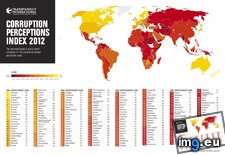
![[Mapporn] 'Scene of fighting from 28 Dec to 19 Jan.' Hand drawn map of advance out of Bastogne by Lt. John Plumb [2187 x 3675] - (#Map #Hand #Scene #Bastogne #Fighting #Jan #Plumb) - 1010 KB Tags: advance, bastogne, dec, drawn, fighting, hand, jan, john, map, plumb, scene (Pict. in My r/MAPS favs)](https://t.im9.eu/mapporn-scene-of-fighting-from-28-dec-to-19-jan-hand-drawn-map-of-advance-out-of-bastogne-by-lt-john-plumb-2187-x-3675-see-corresponding-service-record-in-comments-x-post-from-r-historyporn.jpg) Pict. Corruption Perceptions Index 2012 (map with ranks) - Transparency International (#Map #International #Corruption #Perceptions #Transparency)Pict. 1280×840 px
Pict. Corruption Perceptions Index 2012 (map with ranks) - Transparency International (#Map #International #Corruption #Perceptions #Transparency)Pict. 1280×840 px★ 6991 pts. ♥ 0 aime ⬇ 5 sauvegardés
 Pict. [Mapporn] Map of Lewis and Clark's expedition across America from 1804 - 1806. It changed mapping of northwest America by provid (#Map #America #Changed #Mapping #Expedition #Provid)Pict. 2520×1095 px
★ 6987 pts. ♥ 0 aime ⬇ 12 sauvegardés
![[Mapporn] Map of Lewis and Clark's expedition across America from 1804 - 1806. It changed mapping of northwest America by provid (#Map #America #Changed #Mapping #Expedition #Provid) - 778 KB Tags: america, changed, clark, expedition, lewis, map, mapping, northwest, provid (Pict. in My r/MAPS favs)](https://t.im9.eu/mapporn-map-of-lewis-and-clark-s-expedition-across-america-from-1804-1806-it-changed-mapping-of-northwest-america-by-providing-the-first-accurate-depiction-of-the-relationship-of-the-sources-of-the-columbia-and-missouri-rivers-and-the-rocky-moun.jpg) Pict. [Mapporn] Daylight savings are near in Europe! Map of countries (and territories-states) that currently observe daylight savings (#Map #Europe #States #Savings #Observe)Pict. 900×516 px
Pict. [Mapporn] Daylight savings are near in Europe! Map of countries (and territories-states) that currently observe daylight savings (#Map #Europe #States #Savings #Observe)Pict. 900×516 px★ 6985 pts. ♥ 0 aime ⬇ 6 sauvegardés
![[Mapporn] Daylight savings are near in Europe! Map of countries (and territories-states) that currently observe daylight savings (#Map #Europe #States #Savings #Observe) - 74 KB Tags: countries, daylight, europe, map, observe, savings, states, territories (Pict. in My r/MAPS favs)](https://t.im9.eu/mapporn-daylight-savings-are-near-in-europe-map-of-countries-and-territories-states-that-currently-observe-daylight-savings-900-516.jpg) Pict. [Mapporn] So here's the new version of that map showing the difference between the highest and lowest recorded temperature..[497 (#Map #Showing #Lowest #Temperature #Recorded)Pict. 4972×2517 px
Pict. [Mapporn] So here's the new version of that map showing the difference between the highest and lowest recorded temperature..[497 (#Map #Showing #Lowest #Temperature #Recorded)Pict. 4972×2517 px★ 6983 pts. ♥ 0 aime ⬇ 9 sauvegardés
![[Mapporn] So here's the new version of that map showing the difference between the highest and lowest recorded temperature..[497 (#Map #Showing #Lowest #Temperature #Recorded) - 1.2 MB Tags: difference, highest, lowest, map, recorded, showing, temperature (Pict. in My r/MAPS favs)](https://t.im9.eu/mapporn-so-here-s-the-new-version-of-that-map-showing-the-difference-between-the-highest-and-lowest-recorded-temperature-4972x2517-os.jpg) Pict. [Mapporn] Worldwide map of organized crime (source: United Nations Office on Drugs and Crime) [1488x904] (#Source #Map #Office #Nations #Drugs #Organized)Pict. 1488×904 px
Pict. [Mapporn] Worldwide map of organized crime (source: United Nations Office on Drugs and Crime) [1488x904] (#Source #Map #Office #Nations #Drugs #Organized)Pict. 1488×904 px★ 6974 pts. ♥ 0 aime ⬇ 11 sauvegardés
![[Mapporn] Worldwide map of organized crime (source: United Nations Office on Drugs and Crime) [1488x904] (#Source #Map #Office #Nations #Drugs #Organized) - 143 KB Tags: crime, drugs, map, nations, office, organized, source, united, worldwide (Pict. in My r/MAPS favs)](https://t.im9.eu/mapporn-worldwide-map-of-organized-crime-source-united-nations-office-on-drugs-and-crime-1488x904.jpg) Pict. [Mapporn] Google earth bugged : Map of the roads of Europe, without the cities, the borders, the land or the sea.[1571x976][OC] (#Map #Europe #Earth #Cities #Borders #Roads #Bugged)Pict. 1571×976 px
Pict. [Mapporn] Google earth bugged : Map of the roads of Europe, without the cities, the borders, the land or the sea.[1571x976][OC] (#Map #Europe #Earth #Cities #Borders #Roads #Bugged)Pict. 1571×976 px★ 6972 pts. ♥ 0 aime ⬇ 8 sauvegardés
![[Mapporn] Google earth bugged : Map of the roads of Europe, without the cities, the borders, the land or the sea.[1571x976][OC] (#Map #Europe #Earth #Cities #Borders #Roads #Bugged) - 259 KB Tags: borders, bugged, cities, earth, europe, google, land, map, roads, sea (Pict. in My r/MAPS favs)](https://t.im9.eu/mapporn-google-earth-bugged-map-of-the-roads-of-europe-without-the-cities-the-borders-the-land-or-the-sea-1571x976-oc.jpg) Pict. [Mapporn] Map of the Battle Line in France and Belgium on the 25th of September 1918. A WW1 map made by Ernest Clegg in 1926 [40 (#Map #Battle #France #Ww1 #25th #Ernest #Clegg)Pict. 4098×4112 px
Pict. [Mapporn] Map of the Battle Line in France and Belgium on the 25th of September 1918. A WW1 map made by Ernest Clegg in 1926 [40 (#Map #Battle #France #Ww1 #25th #Ernest #Clegg)Pict. 4098×4112 px★ 6971 pts. ♥ 0 aime ⬇ 7 sauvegardés
![[Mapporn] Map of the Battle Line in France and Belgium on the 25th of September 1918. A WW1 map made by Ernest Clegg in 1926 [40 (#Map #Battle #France #Ww1 #25th #Ernest #Clegg) - 4.6 MB Tags: 25th, battle, belgium, clegg, ernest, france, line, map, september, ww1 (Pict. in My r/MAPS favs)](https://t.im9.eu/mapporn-map-of-the-battle-line-in-france-and-belgium-on-the-25th-of-september-1918-a-ww1-map-made-by-ernest-clegg-in-1926-4098x4112.jpg) Pict. [Mapporn] Topographical world map with accurate currents done with paper quilling by Amber Rousse (quilling) [3401 x 1921] (#World #Map #Amber #Topographical #Currents #Quilling)Pict. 3400×1920 px
Pict. [Mapporn] Topographical world map with accurate currents done with paper quilling by Amber Rousse (quilling) [3401 x 1921] (#World #Map #Amber #Topographical #Currents #Quilling)Pict. 3400×1920 px★ 6967 pts. ♥ 0 aime ⬇ 2 sauvegardés
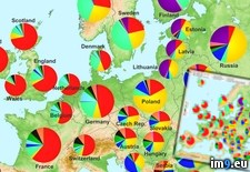
![[Mapporn] Topographical world map with accurate currents done with paper quilling by Amber Rousse (quilling) [3401 x 1921] (#World #Map #Amber #Topographical #Currents #Quilling) - 1.3 MB Tags: accurate, amber, currents, map, paper, quilling, rousse, topographical, world (Pict. in My r/MAPS favs)](https://t.im9.eu/mapporn-topographical-world-map-with-accurate-currents-done-with-paper-quilling-by-amber-rousse-quilling-3401-x-1921.jpg) Pict. The genetics of Europe (map with piecharts) (#Map #Europe #Genetics #Piechart #Piecharts)Pict. 986×1118 px
Pict. The genetics of Europe (map with piecharts) (#Map #Europe #Genetics #Piechart #Piecharts)Pict. 986×1118 px★ 6952 pts. ♥ 0 aime ⬇ 10 sauvegardés
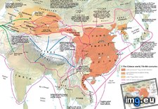
 Pict. mapporn-the-chinese-world-7th-8th-centuries-1-253-923 (#White #World #Map #Best #Average #Maps #Asia #Centuries)Pict. 1253×923 px
★ 6947 pts. ♥ 0 aime ⬇ 2 sauvegardés
 Pict. [Mapporn] Map of a potential NW US-SW Canada nation based on ecological boundaries [960x741] (#Map #Canada #Based #960x741 #Ecological)Pict. 960×741 px
★ 6942 pts. ♥ 0 aime ⬇ 5 sauvegardés
![[Mapporn] Map of a potential NW US-SW Canada nation based on ecological boundaries [960x741] (#Map #Canada #Based #960x741 #Ecological) - 135 KB Tags: 960x741, based, boundaries, canada, ecological, map, nation, potential (Pict. in My r/MAPS favs)](https://t.im9.eu/mapporn-map-of-a-potential-nw-us-sw-canada-nation-based-on-ecological-boundaries-960x741.jpg) Pict. [Mapporn] Map of Europe showing the non-immigrant native population percentages [1984x1736] (#Map #Europe #Showing #Immigrant #Percentages)Pict. 1984×1736 px
Pict. [Mapporn] Map of Europe showing the non-immigrant native population percentages [1984x1736] (#Map #Europe #Showing #Immigrant #Percentages)Pict. 1984×1736 px★ 6938 pts. ♥ 0 aime ⬇ 14 sauvegardés
![[Mapporn] Map of Europe showing the non-immigrant native population percentages [1984x1736] (#Map #Europe #Showing #Immigrant #Percentages) - 277 KB Tags: europe, immigrant, map, native, non, percentages, population, showing (Pict. in My r/MAPS favs)](https://t.im9.eu/mapporn-map-of-europe-showing-the-non-immigrant-native-population-percentages-1984x1736.jpg)